TouchScreenTravels logo

TouchScreenTravels

Our Touch, your Travels…

This is a preview of the full content of our York’s Best app.

Please consider downloading this app to support small independent publishing and because:

  • All content is designed for mobile devices and works best there.
  • Detailed in-app maps will help you find sites using your device’s GPS.
  • The app works offline (one time upgrade required on Android versions).
  • All advertising (only present on Android versions) can be removed.

The app will also allow you to:

  • Add custom locations to the app map (your hotel…).
  • Create your own list of favourites as you browse.
  • Search the entire contents using a fast and simple text-search tool.
  • Make one-click phone calls (on phones).
iOS App Store Google Play

Stonegate

A medieval street along a Roman route

In Roman York this street was called via praetoria. Stonegate led from the army's headquarters (on the site of the Minster) down to the ships on the River Ouse.

In medieval times the street was used to transport the stones up from the barges for the building of the Minster.

With its medieval buildings, the street now has small shops, cafés and pubs (including Ye Olde Starre Inne, with its unusual beam sign straddling the street).

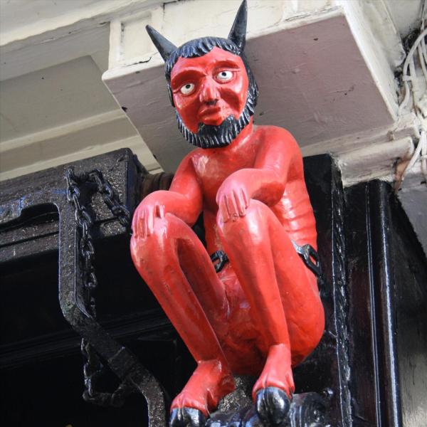
Check out the red printer's devil on the wall by Coffee Yard, a reminder of a former printing shop in the building. (A less well-known ornament in the street is the gloomy lady taken from a ship's prow and now adorning number 13. This is usually missed by visitors.)

Tip For a short side trip off Stonegate, follow the Coffee Yard snickelway leading off Stonegate by the printers devil to Grape Lane, former red light area of Medieval York.

TIME Allow around an hour

Practical Info Practical Info icon

LOCATION Minster Area

Stonegate

1200–1600: Medieval York

The Minster Area

York In-A-Day

A day in the capital of "God's own county"

Text © Raymond Williams

Image by